
Advertisement
Amazing video of inside the eye of Hurricane Dorian
Sep 02, 2019
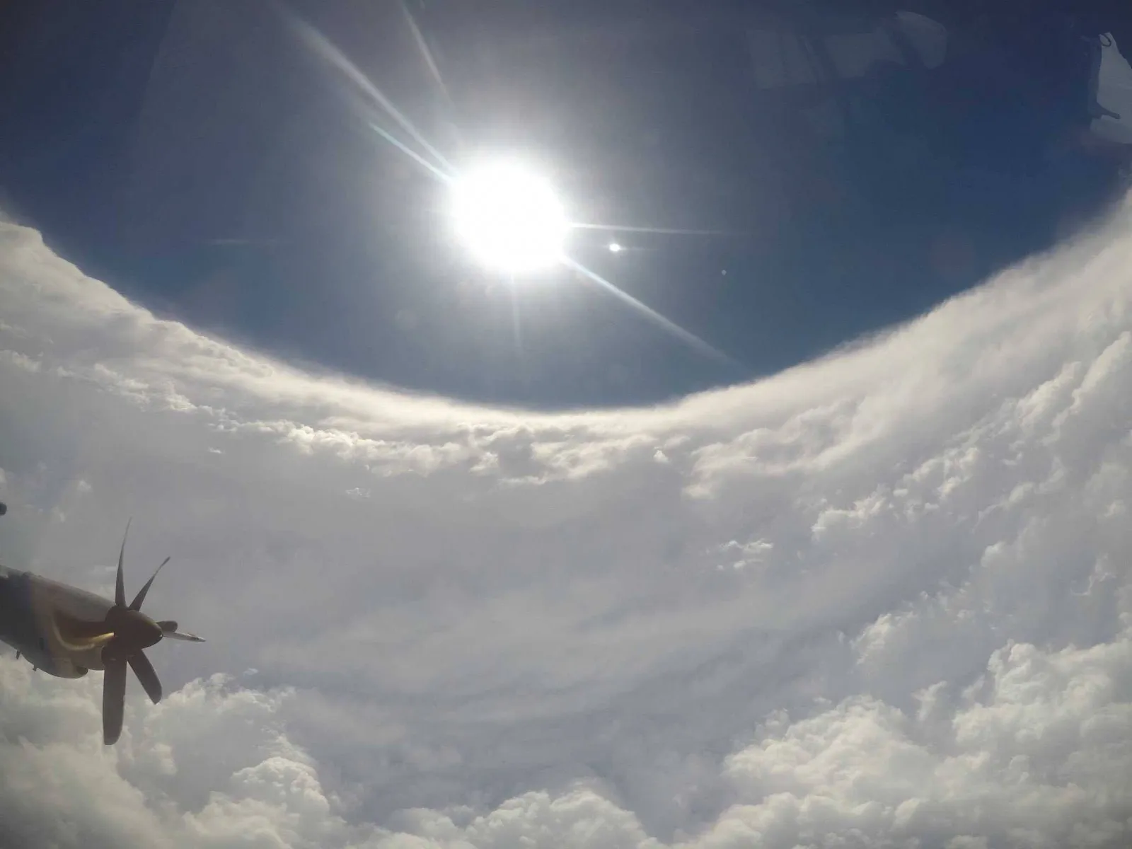
A remarkable video captures the breathtaking view inside Hurricane Dorian, showcasing the storm's immense power and structure. The footage reveals a swirling mass of clouds and winds, with the eye of the hurricane appearing eerily calm at its center. As the camera pans, viewers witness the dramatic contrast between the chaotic outer bands and the serene core. The video highlights the intricate patterns of the storm, emphasizing the sheer scale and intensity of one of nature's most formidable forces. This stunning visual experience offers a unique perspective on the dynamics of hurricanes and their impact on the environment.
As Hurricane Dorian approached the southeastern United States in September 2019, stunning footage emerged from the heart of the storm. This remarkable video provided an unprecedented view inside the eye of Hurricane Dorian, showcasing the raw power of nature. The video captured the swirling clouds, intense winds, and the eerie calm at the storm's center, making it a compelling watch for meteorologists and storm enthusiasts alike.
Understanding Hurricane Dorian
Hurricane Dorian was categorized as a Category 5 hurricane, which is the highest rating on the Saffir-Simpson Hurricane Wind Scale. This scale measures the potential damage a hurricane can cause, with Category 5 storms having sustained winds of 157 mph or higher. Dorian was notable not only for its intensity but also for its prolonged impact on the Bahamas and the eastern coast of the United States.
Analyzing the Video Footage
The video footage released from inside the eye of Hurricane Dorian revealed several fascinating aspects of the storm. The eye of a hurricane is typically characterized by calm winds and clear skies, surrounded by the more turbulent eyewall, where the most severe weather occurs. In Dorian's case, the video illustrated the stark contrast between the chaos of the eyewall and the tranquility of the eye.
Key points observed in the video include:
| Aspect | Description |
|---|---|
| Wind Speed | Reaching over 180 mph in the eyewall |
| Eye Diameter | Approximately 30 miles wide |
| Cloud Structure | Well-defined spiral bands surrounding the eye |
| Temperature | Noticeably warmer inside the eye |
The Technology Behind the Footage
Capturing such incredible footage requires advanced technology and skilled operation. Dorian's video was made possible by reconnaissance aircraft from the National Oceanic and Atmospheric Administration (NOAA) and the U.S. Air Force Reserve. These aircraft, equipped with sophisticated instruments, penetrate the storm to gather critical data and provide real-time updates on hurricane conditions.
Additionally, satellite imagery played a crucial role in visualizing the storm’s structure. This combination of aerial and satellite data is essential for meteorologists to forecast the hurricane's path and intensity accurately.
The Impact of Hurricane Dorian
Hurricane Dorian had devastating effects, particularly in the Bahamas, where it made landfall as a Category 5 storm. The destruction was catastrophic, leading to significant loss of life and property. Dorian's aftermath prompted discussions about the importance of preparedness, the impact of climate change on hurricane intensity, and the need for improved infrastructure in vulnerable regions.
In the U.S., Dorian created havoc with severe flooding, power outages, and evacuation orders along the East Coast. The Federal Emergency Management Agency (FEMA) and local organizations mobilized to provide assistance, highlighting the importance of community readiness in facing such natural disasters.
Educational Value of the Video
Beyond its stunning visuals, the video of Hurricane Dorian serves an educational purpose. It provides insights into hurricane formation, structure, and behavior. Schools and educational institutions can use this footage to teach students about meteorology, climate science, and environmental awareness.
For instance, students can learn about:
- The anatomy of a hurricane, including the eye, eyewall, and rainbands
- The factors that contribute to hurricane development, such as sea surface temperatures and atmospheric conditions
- The importance of early warning systems and how technology aids in storm tracking
Future Implications
The lessons learned from Hurricane Dorian and the captivating video footage can help improve future hurricane preparedness and response strategies. Understanding the behavior of storms can lead to better forecasting models, allowing communities to better prepare for and respond to these natural disasters.
Moreover, as climate change continues to influence weather patterns, the study of hurricanes like Dorian becomes increasingly crucial. Researchers are focused on understanding how warming oceans and changing atmospheric conditions may affect hurricane frequency and intensity in the future.
Conclusion
The video capturing the inside of Hurricane Dorian is a breathtaking reminder of nature's power. It not only highlights the beauty and danger of hurricanes but also serves as an educational tool that can inform future generations about the importance of meteorology and disaster preparedness. As we continue to study and learn from such events, we must also focus on resilience and adaptation in the face of a changing climate.


Advertisement
Related Articles

Explore Thailand: The Best Islands to Visit for Paradise, Adventure, and Relaxation

The Ultimate Guide to the Best Islands in Thailand for Your Next Getaway

Do babies need passports? How to get a passport for a newborn

How to get a U.S. passport fast: here’s how to expedite the process
What is Mobile Passport Control: 5 reasons why you should use it

SENTRI vs. Global Entry: A detailed guide

Do you need a passport to go to the Bahamas? Let’s find out

Do you need a passport to go to Mexico? A detailed guide

Do you need a passport to go to Canada? We got the answer

Do You Need a Passport for a Cruise: An Essential Travel Guide

Booster Seat Requirements: All the Rules to Follow in Your Rental Car

What Are the World’s Most Powerful Passports, and How Does Yours Rank?

How to Take a Passport Photo at Home: A Helpful Guide

You've got to have heart! Southwest's new livery

Your opinion: Should water be free on low cost carriers?

Young women bolder than guys as solo travellers